Research Interests
-
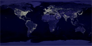
I have many interests spanning much of geography but ranging into ecology, economics, and philosophy. Most of my research focuses on applied issues associated with the Human-Environment-Sustainability problematic. I do a great deal of work with nighttime satellite imagery derived from the Defense Meteorological Satellite Program’s Operational Linescan System (DMSP OLS). Data products derived from DMSP OLS imagery are being used to map and estimate human population distribution, energy consumption, economic activity, urban extent, CO2 emissions, and more. The tools needed to engage in this research are remote sensing , geographic information analysis, and statistics. I also am interested in the development of the discipline of ecological economics. I use my expertise in GIS and spatial data analysis in collaborations with economists and ecologists to make spatially explicit valuations of ecosystem services. Nonetheless my interests are quite broad and I have had students write theses and dissertations in areas ranging from crime mapping to explaining ‘high-stakes’ testing scores in the public schools to mapping invasive species.
Ongoing Research Activities
The NightSat Mission
I serve on the science team of a $150 million proposal to NASA (The P.I. is Chris Elvidge of the National Geophysical Data Center at NOAA in Boulder). As an Urban Metabolism Scientist, I will be responsible to the PI for conducting research that identifies and documents how the improved spatial and spectral resolution of NightSat data products will inform our understanding of the human-environment-sustainability problematic as it pertains to the following: urban growth and land use patterns, mapping and monetizing the human ecological footprint, and characterizing the megapolitan-urban-exurban gradient and its impacts on ecosystem function, habitat fragmentation, and ecosystem services.
Geo-location and Radiance Calibration of the DMSP OLS Sensor
I have been using data products derived from the Defense Meteorological Satellite Program’s Operational Linescan System (DMSP OLS) for myriad applications. This work has contributed to the justification for the aforementioned NightSat mission. The coarse spatial and spectral resolution of the DMSP OLS presents many uncertainties with respect to spatial and radiometric accuracy of the sensor. I have been working with Dr. Sharolyn Anderson and her PhD student (Benjamin Tuttle) on characterizing and calibrating the DMSP OLS imagery by lighting up pixels in dark places using our own light source.
Valuation of Ecosystem Services
I began a working relationship with Robert Costanza back in my days as a graduate student at UCSB in which I participated in the writing of a paper published in Nature titled: The value of the world’s ecosystems and natural capital. As a result of this I became interested in the development of the discipline of ecological economics. Dr. Costanza and I have worked together on several other papers involving the interesting problems associated with trying to assign dollar values to ecosystem services. I use my expertise in GIS and spatial data analysis in collaborations with economists and ecologists to make spatially explicit valuations of ecosystem services.
Development of independent and objective Sustainability Metrics
I have had a long interest in the idea of carrying capacity going back to my days as president of the Santa Barbara Chapter of Zero Population Growth and conversations with Paul Ehrlich, Garrett Hardin, Hunter Lovins, and Jared Diamond. I have developed some simple, easy to measure, and objective metrics of sustainability that correlate strongly with well-established metrics such as the Global Footprint Network’s ‘Ecological Footprint’. I collaborate with Alessandro Galli of the Global Footprint Network in this area.
Mapping Economic Activity using Nighttime Satellite imagery
I worked closely with one of my PhD Students, Tilottama Ghosh, in the modeling of economic activity using the DMSP OLS data products. She successfully developed methods for estimating the fraction of the national economy of India and Mexico that is in the informal sector and mapped it. She also produced the first global map of GDP/capita at 1 km2 spatial resolution. This work relating the estimation and mapping of economic activity using nocturnal satellite observations is gaining traction with researchers at Yale and UCLA.
Issues of Scale and Representation in Geographic Data
Figuring out how best to represent spatially and temporally varying phenomena in a digital environment is a fascinating problem of scale, classification, and abstraction. The simple idea of representing the spatio-temporal variation of intra-urban population density is a good example of how this is not really a simple idea. In my efforts at modeling proxy measures of population density, economic activity, and ecosystem service value I have enjoyed struggling with these insurmountable problems and hope to make some contributions to methods that will inform our understanding of the roles these phenomena play in questions of sustainability.
Measuring Learning Outcomes for undergraduate Geography Students
I am becoming increasingly interested in what it is, exactly, that we believe we are teaching to undergraduate geography students. I am appalled at the simplistic ways in which we use end of course student evaluations to measure teaching effectiveness. I applaud efforts at the development of instruments such as the AP Human Geography exam that attempt to actually measure what students of Geography have presumably learned. I intend to participate in this clarification of ‘Learning Outcomes’ for undergraduate degrees in Geography for the rest of my career because I think it is imperative that we as faculty in this discipline can answer questions like: “What will I learn from taking a degree in Geography that I won’t learn from taking some other degree?”